Last Post on James’ St

Having served the area since 1891, James’ St post office recently closed and is currently for lease. It was one of several post offices designed by “the always interesting” J. Howard Pentland. Others in Dublin include Ballsbridge, Phibsborough (demolished and rebuilt in 1960), and Blackrock in 1909.  Maire Crean’s magnificent book “Lost Post” provides substantial detail on James’ St post office, including the original proposal of the floor plan, now kept in the National Archives.
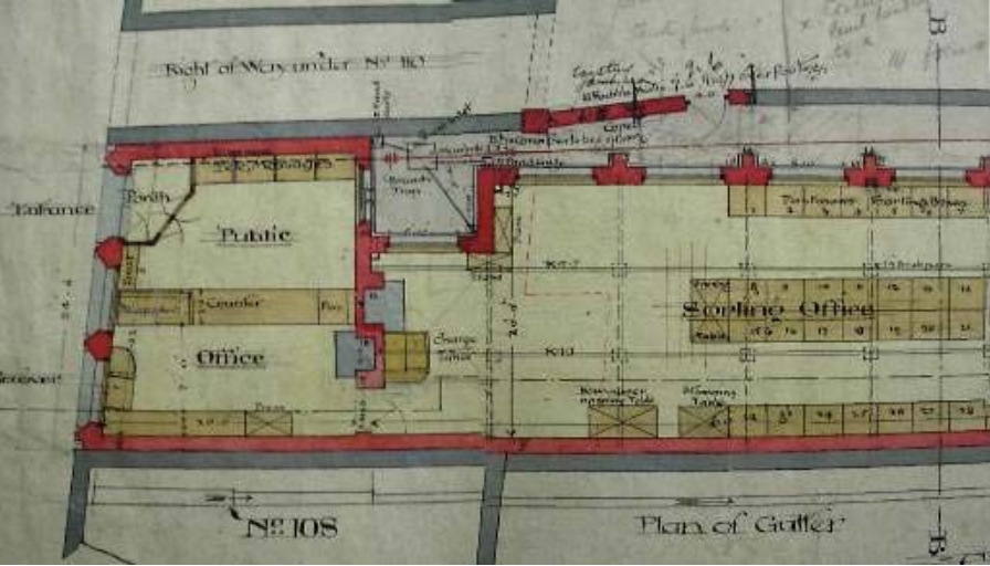
James’s Street Former P.O.; Part Original Ground Floor Plan (National Archives of Ireland, reproduced in Crean)

James’s Street Former P.O.; Part Original Ground Floor Plan (National Archives of Ireland, reproduced in Crean).

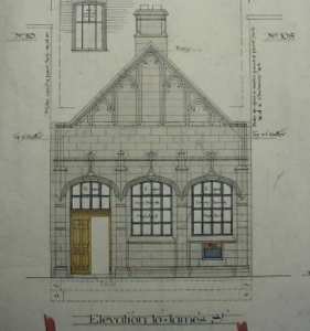
James’s Street Former P.O.; Original Elevation (National Archives of Ireland, reproduced in Crean).

James’s Street P.O.; Original Elevation (National Archives of Ireland, reproduced in Crean).

The public office is visible to the left of the plan, and the sorting office to the right. Crean also treats us to the original elevation – clearly it was originally intended to be a Gothic affair. The door to the public office is on the left on the plans, but from the existing building, we can see it is on the right.

The existing building is part of a trio of red-bricked buildings on the site: two at the pavement, and one in between; a three-storey building recessed from the road. Casey seems doubtful that such a grand building could be for a postmaster, and I can’t find anything in the 1901 Census to counter her opinion. The Post Office in that Census was given number 106, and was of course uninhabited. Using that numbering system, 105 and 104 are the adjoining buildings, and they too were unoccupied in 1901. By 1911, the numbering had shifted to what we currently have: the post office at no. 109, and the large house at 108 was a boarding house for four brewers from England and four domestic servants. 107 remained unoccupied.

Penny Post History

Stafford Johnson gained a substantial amount of information from two pieces of paper found in a bin. Most other remaining archives were destroyed.

Postal history can be traced back to James’ St much earlier than 1892. Dublin had an innovative and efficient postal system known as the “Penny Post”, which was established in 1773. The city joined London to be unique in the world with such a system, although according to Stafford Johnson—who has provided us with one of the rare monographs on this topic—Dublin “has some matter for pride in the fact that it maintained the general character of the Penny Post unaltered until the end.

The Penny Post operated in parallel to the pre-existing General Post system. From 11th October 1773, letters not exceeding four ounces could be delivered from the Penny Post Office in the GPO yard or any of eighteen Receiving Houses around the city, at a cost of one penny. The receiving houses were named in the original correspondence and included Mr. Charles Wren, Hosier, at the Sign of the Stocking, Francis-street near the Combe, Mr. Bredberry, Grocer, at the Sign of the three Swedish Crowns, George’s Quay and Mr. Bourke, Grocer at the Black Boy and Sugar Loaf, Capel-street near Essex-bridge. By 1810, there were 54 receiving houses in the city, and 29 country receiving houses, the extra distance to the country (suburban areas) costing 2 pence.

Doorway, James St Post Office

Doorway, James’ St Post Office (Photo: B)

The original system involved a pre-payment of one penny which was given in to the Penny Post Office or receiving houses. Letters that did not have the accompanying penny were opened and returned to the sender. A plea was made to be as precise as possible with the address, and those intended for lodgers were to name the landlord or the sign (on the building) to assist the post men.These men wore a distinctive uniform from 1810, and like their colleagues in the General Post system, rang a bell when on collection duty.

In 1810, the pre-payment system was abandoned. The official reason isn’t known, but Stafford Johnson offers with some confidence his theory that pre-payment ran counter to the public sentiments of the time. Payment on delivery would be preferred as it secured a safer delivery, and poorer people could take advantage of the system by refusing to accept delivery (and hence avoid the charge) while learning who the letter was from. Apparently secret codes were used so that the recipient could interpret the message with accepting the letter. Nonetheless, the system was a successful and efficient means of communication in the city. The post-masters general were eager to highlight the benefit of their system and regularly published the notice:

So expeditious and regular is the dispatch and delivery of letters by this Office that two persons residing in the most distant parts of the City from each other, may write four letters and receive three answers in the day for the trifling expense of one penny on each.

James St Post Office (Photo: B)

James’ St Post Office (Photo: B)

Back at James’ St, a receiving house opened on the street in 1809/10, and we can propose that this house is a precursor to the post office mentioned at the head of the article. The listing of a receiving house at No. 75 in the 1862 street directory adds some weight to this proposal. Here, William Madden, M.D. operated his medical practice, and acted as a Post Office Receiver. In addition to the house on James’ St, a second receiving house opened on Echlin Lane (now Echlin St) after 1810. The latter joined receiving houses at Broadstone Hotel and Portobello Hotel linking the city system with the Royal and Grand canal harbours (see In the fields off James’ St).

The Penny Post system ended in 1840, because of a combination of factors, not least the duplication with the General Post system. Stafford Johnson closes his article with the following:

Looked at as a whole, the Penny Post was worthy of the City and fulfilled its functions truly and well. For 66 years it gave a service which for cheapness and quickness has never been equalled. All this was done by men on foot, and to-day, in spite of the advantages of modern science, there is nothing to come up to that old system of which all that remains is a memory and some faded old letters.

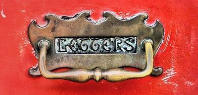
Letter Box on No 107 James St

Letter Box on No 107 James’ St (Photo: B)

You can receive email updates when a new post is published by subscribing below.

Notes

In the fields off James’ St

Grand Canal Place
at the second hour.
Live lights on oiled water
in the terminus harbor.

Thomas Kinsella, St Catherine’s Clock

Walking around between the Guinness Storehouse and St James’ Hospital, there are some aqueously named streets: Grand Canal Place, Basin View, Basin Lane Upper. Water, water, everywhere. But neither eyes nor satellite show any sight of a drop.

Rocque to the rescue, as always. Tucked away in the south-western corner of his 1756 plan of the city is “City Bason”. The Bason, or Basin was a reservoir supplying this area of the city-especially the ever growing number of breweries and distilleries-with water. It was also a place for local residents to escape the confines of the city’s streets.

Rocque's map of the city - the "city bason" is just on the southern edge of the extract shown.

Rocque’s map of the city – the “city bason” is just on the southern edge of the extract shown.

With the aid of your monocle, it can be seen that a tree-lined walkway is shown around the basin, and the area was popular as a promenade, so much so that it had already been included as a panel of interest in Brooking’s map of 1728. In addition, it was a venue for musical performances. A concert in aid of the Meath Hospital advertised for August 1756, the date of Rocque’s map, promised a performance of Ellen-a-Roon by Mr Pockrich, playing musical glasses:

Mr. Pockrich hath, (in consideration of so useful a Charity) condescended to exhibit a NEW and CURIOUS Musical Instrument, invented by him very lately, the Effects of which it is impossible to describe, as being entirely different from all either Wind or String Instruments …

It would appear on this particular occasion, that Mr Pockrich’s performance didn’t go well. A subsequent apology appeared from the man himself in the following week’s newspaper: the cause of disappointment was his adding a Glass too much to his instrument. 

Ordnance Survey of Ireland map of area south of James' St. (Map: OSi)

Ordnance Survey of Ireland map of area south of James’ St. (Map: OSi)

We digress. The City Basin, Frank Cullen tells us in his fantastic new book was built in 1724, and indeed by the date of the Ordnance Survey map over a century later, the tree lined promenade was still present. A guide to the city in 1835 reported that:

The City Bason is the pleasantest, most elegant and sequestered place of relaxation the citizens can boast of; the reservoir, which in part supplies the city with water, is mounded and terraced all round, and planted with quickset hedges, limes and elms, having beautiful green walks between, in a situation which commands a most satisfactory prospect of a vast extent of fine country to the south. The entrance is elegant, by a lofty iron gate, and the water that supplies it, is conveyed from the neighbouring mountains.

The basin is important for the next part of the story. Its location probably directed the choice of the end of the Grand Canal adjacent to it, completed in 1785. The Canal would serve to keep water flowing to the basin, and hence to the city. (It wasn’t until 1790 that the canal was extended along the South Circular Road to the Liffey.)

Thus the terminus in the quote from Kinsella above makes sense. Quite an extensive harbour and dry docks are visible in the Ordnance Survey map, and the whole complex meant that this became an important link between Dublin, especially the Liberties and surrounding area, and the rest of the country via the canal. It’s probably no coincidence that the street running east from the harbour, that which now runs along by the entrance of the Guinness Storehouse, is called Market St. Gloriously, a sketch of the area published in the Illustrated London News and reproduced by Cullen gives us a picture of the locality in 1846.

City Basin and Grand Canal Harbour, Illustrated London News, 1846, reproduced in Cullen (2015)

City Basin and Grand Canal Harbour, Illustrated London News, 1846, and reproduced in Cullen (2015). The South Dublin Union Workhouse is visible to the west.

At this time, the area east of the Basin and south of James’ St had not been assimilated into the Guinness empire and one can see (pass the monocle again dear) on both the map and the etching that the area is primarily residential. In this final part, we’ll consider two developments that emerged in the nineteenth century.

Rocque's 1757 map showing what became known as "Old James's Gate Chapel" on the corner of Watling St, erected 1749.

Rocque’s 1757 map showing what became known as “Old James’s Gate Chapel” (marked with a cross) on the corner of Watling St, erected 1749.

The first is Echlin St, dominated on the east by St James’ Church. This is the third incarnation of the church; a Chapel of St James was erected by Canon Matthew Kelly in what was known as Jennet’s Yard. This lasted until 1749, when Richard Fitzsimons PP built a church on the corner of Watling St. (Rocque kindly marks a building with a cross at this location.) In August 1852 the present St James’ Church was opened by Dr, later Cardinal Paul. A notice outside the church says that Daniel O’Connell laid the foundation stone. Echlin St links James St with Grand Canal Place. Previously named Echlin Lane, it sourced its title from Rev Henry Echlin, who was the vicar of St James until his death in 1752.

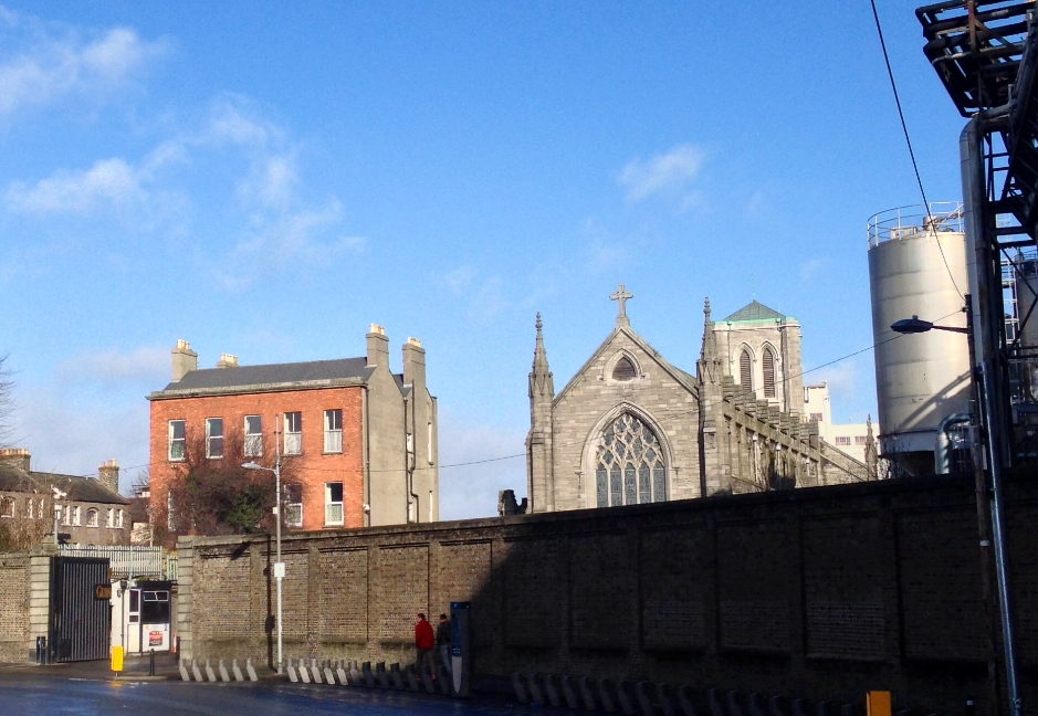
St James' Church from Grand Canal Place

St James’ Church from Grand Canal Place

Secondly, the large curved building wrapped around Grand Canal Place is not present on the maps or views of the 1840s. This building, which Cullen describes as warehouses and Casey describes as experimental maltings were built by Guinness in 1863; in either case a convenient location on the water’s edge for distribution nationwide.  Facing inwards towards the canal, which like the basin beside it is now filled in, it is the last remnant of the enormous water complex that supported this industrial quarter of the city. One can contemplate Kinsella’s Live lights on oiled water in the Harbour Bar pub just across the road.

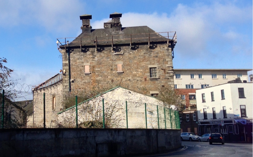
At Grand Canal Place

At Grand Canal Place. The Harbour Bar is the white building to the right.

You can receive email updates when a new post is published by subscribing below.

Notes

  • There is a photo essay of this area on the Irish Waterways History website.
  • Brian Boydell (1991) Mr. Pockrich and the Musical Glasses, Dublin Historical Record, 44(2), 25-33.
  • Christine Casey (2005) The Buildings of Dublin, Yale University Press.
  • Frank Cullen (2015) Dublin 1847: City of the Ordnance Survey, RIA (Dublin).
  • Desmond F. Moore (1960) The Guinness Saga, Dublin Historical Record, 16(2), 50-57.