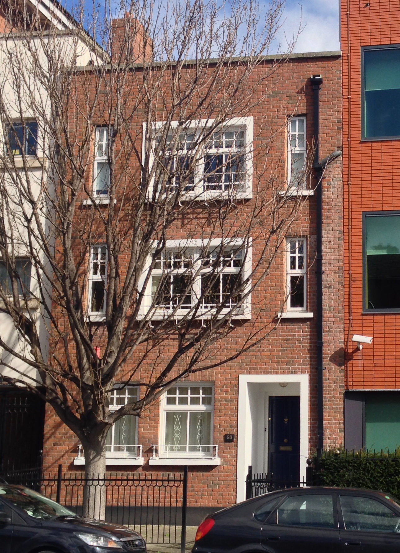
In the fields off James’ St

Grand Canal Place
at the second hour.
Live lights on oiled water
in the terminus harbor.

Thomas Kinsella, St Catherine’s Clock

Walking around between the Guinness Storehouse and St James’ Hospital, there are some aqueously named streets: Grand Canal Place, Basin View, Basin Lane Upper. Water, water, everywhere. But neither eyes nor satellite show any sight of a drop.

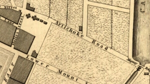
Rocque to the rescue, as always. Tucked away in the south-western corner of his 1756 plan of the city is “City Bason”. The Bason, or Basin was a reservoir supplying this area of the city-especially the ever growing number of breweries and distilleries-with water. It was also a place for local residents to escape the confines of the city’s streets.

Rocque's map of the city - the "city bason" is just on the southern edge of the extract shown.

Rocque’s map of the city – the “city bason” is just on the southern edge of the extract shown.

With the aid of your monocle, it can be seen that a tree-lined walkway is shown around the basin, and the area was popular as a promenade, so much so that it had already been included as a panel of interest in Brooking’s map of 1728. In addition, it was a venue for musical performances. A concert in aid of the Meath Hospital advertised for August 1756, the date of Rocque’s map, promised a performance of Ellen-a-Roon by Mr Pockrich, playing musical glasses:

Mr. Pockrich hath, (in consideration of so useful a Charity) condescended to exhibit a NEW and CURIOUS Musical Instrument, invented by him very lately, the Effects of which it is impossible to describe, as being entirely different from all either Wind or String Instruments …

It would appear on this particular occasion, that Mr Pockrich’s performance didn’t go well. A subsequent apology appeared from the man himself in the following week’s newspaper: the cause of disappointment was his adding a Glass too much to his instrument. 

Ordnance Survey of Ireland map of area south of James' St. (Map: OSi)

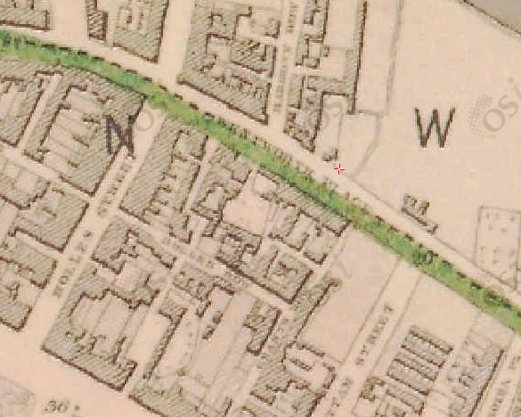
Ordnance Survey of Ireland map of area south of James’ St. (Map: OSi)

We digress. The City Basin, Frank Cullen tells us in his fantastic new book was built in 1724, and indeed by the date of the Ordnance Survey map over a century later, the tree lined promenade was still present. A guide to the city in 1835 reported that:

The City Bason is the pleasantest, most elegant and sequestered place of relaxation the citizens can boast of; the reservoir, which in part supplies the city with water, is mounded and terraced all round, and planted with quickset hedges, limes and elms, having beautiful green walks between, in a situation which commands a most satisfactory prospect of a vast extent of fine country to the south. The entrance is elegant, by a lofty iron gate, and the water that supplies it, is conveyed from the neighbouring mountains.

The basin is important for the next part of the story. Its location probably directed the choice of the end of the Grand Canal adjacent to it, completed in 1785. The Canal would serve to keep water flowing to the basin, and hence to the city. (It wasn’t until 1790 that the canal was extended along the South Circular Road to the Liffey.)

Thus the terminus in the quote from Kinsella above makes sense. Quite an extensive harbour and dry docks are visible in the Ordnance Survey map, and the whole complex meant that this became an important link between Dublin, especially the Liberties and surrounding area, and the rest of the country via the canal. It’s probably no coincidence that the street running east from the harbour, that which now runs along by the entrance of the Guinness Storehouse, is called Market St. Gloriously, a sketch of the area published in the Illustrated London News and reproduced by Cullen gives us a picture of the locality in 1846.

City Basin and Grand Canal Harbour, Illustrated London News, 1846, reproduced in Cullen (2015)

City Basin and Grand Canal Harbour, Illustrated London News, 1846, and reproduced in Cullen (2015). The South Dublin Union Workhouse is visible to the west.

At this time, the area east of the Basin and south of James’ St had not been assimilated into the Guinness empire and one can see (pass the monocle again dear) on both the map and the etching that the area is primarily residential. In this final part, we’ll consider two developments that emerged in the nineteenth century.

Rocque's 1757 map showing what became known as "Old James's Gate Chapel" on the corner of Watling St, erected 1749.

Rocque’s 1757 map showing what became known as “Old James’s Gate Chapel” (marked with a cross) on the corner of Watling St, erected 1749.

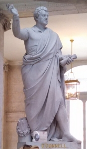
The first is Echlin St, dominated on the east by St James’ Church. This is the third incarnation of the church; a Chapel of St James was erected by Canon Matthew Kelly in what was known as Jennet’s Yard. This lasted until 1749, when Richard Fitzsimons PP built a church on the corner of Watling St. (Rocque kindly marks a building with a cross at this location.) In August 1852 the present St James’ Church was opened by Dr, later Cardinal Paul. A notice outside the church says that Daniel O’Connell laid the foundation stone. Echlin St links James St with Grand Canal Place. Previously named Echlin Lane, it sourced its title from Rev Henry Echlin, who was the vicar of St James until his death in 1752.

St James' Church from Grand Canal Place

St James’ Church from Grand Canal Place

Secondly, the large curved building wrapped around Grand Canal Place is not present on the maps or views of the 1840s. This building, which Cullen describes as warehouses and Casey describes as experimental maltings were built by Guinness in 1863; in either case a convenient location on the water’s edge for distribution nationwide.  Facing inwards towards the canal, which like the basin beside it is now filled in, it is the last remnant of the enormous water complex that supported this industrial quarter of the city. One can contemplate Kinsella’s Live lights on oiled water in the Harbour Bar pub just across the road.

At Grand Canal Place

At Grand Canal Place. The Harbour Bar is the white building to the right.

You can receive email updates when a new post is published by subscribing below.

Notes

  • There is a photo essay of this area on the Irish Waterways History website.
  • Brian Boydell (1991) Mr. Pockrich and the Musical Glasses, Dublin Historical Record, 44(2), 25-33.
  • Christine Casey (2005) The Buildings of Dublin, Yale University Press.
  • Frank Cullen (2015) Dublin 1847: City of the Ordnance Survey, RIA (Dublin).
  • Desmond F. Moore (1960) The Guinness Saga, Dublin Historical Record, 16(2), 50-57.

A little Off

Off Lane, which appears on Rocque’s 1756 map was so named by Henry Moore, 3rd Viscount Moore, 1st Earl of Drogheda who came into possession of lands in this area around what is now the Spire on O’Connell St in 1661 following the Restoration of the Monarchy. Laying out the streets, Henry was clearly a man who wished to leave a legacy. He named some of his new streets Henry St, Moore St, Earl St (now North Earl St), Drogheda St, Mellefont Place (which was Tucker’s Row and became Cathedral St). A small lane, now called Henry Place, linking Moore St to Henry St was called Of or Off Lane. Clearly Henry had used every other combination of his titles, and was left with using the prepositions.

Rocque's Map of 1756 showing Moore's legacy: Moore St, Henry St, Off Lane, Drogheda St and Earl St are all visible.

Rocque’s Map of 1756 showing Henry Moore, Earl of Drogheda’s legacy:  Henry St, Moore St, Earl Street, Off Lane, and Drogheda St

This entire development was laid out before 1728 on what was called Ash Park by the monks of St Mary’s Abbey, where the Earl of Drogheda had taken the Abbot’s House as his city residence. After laying out his new streets, the Earl built Drogheda House, a mansion situated between Earl St and the next street north, now called Cathedral St. The Earl, clearly not wanting to waste an opportunity, called this street Mellefont Place (he was also Baron Moore of Mellefont). A fountain was situated at the front of the house, “pouring water into Drogheda St”. Drogheda St, linking Sackville St (northern end) to the river was by then only a narrow lane, and indeed on Rocque’s map, did not continue to the river.

Sackville St and Gardiner's Mall, c. 1760, by Oliver Grace

Sackville St and Gardiner’s Mall, c. 1760, by Oliver Grace

Wide Street Commissioners Map of planned alterations to Sackville St - compare the width of Sackville and Drogheda Streets. (Dublin City Library - click image to go to source)

Wide Street Commissioners Map of planned alterations to Sackville St – compare the width of Sackville and Drogheda Streets. (Dublin City Library – click image to go to source)

An important map in the Dublin City Library Wide Street Commission archives is shown, outlining the commission’s plans to extend and widen the thoroughfare from the end of Drogheda St through the connection with Abbey St and onto the river. Just 30 years earlier, this was a haphazard cluster of houses. Having widened the section from the river to Abbey St, and the previous widening in 1749 of what became Sackville St, Drogheda’s days were numbered, and the entire length was widened in the 1790s, becoming Sackville St (after a brief time as New Sackville St). This was achieved by Luke Gardiner, later 1st Viscount Mountjoy.

The change from Drogheda to Sackville reflects also the earlier changing land ownership. Drogheda’s reign came to an end following the death of the Earl. The lands passed through the hands of Sir Humphrey Jervis, who sold them to Luke Gardiner around 1714. It was he who laid out Gardiner’s Mall, and the northern stretch of Sackville St; the name coming from Lionel Cranfield Sackville, 1st Duke of Dorset, who was viceroy for the periods 1731-37 and 1751-6.  Gardiner also called his younger son Sackville, so we can assume the families were friendly. As mentioned we had to wait until his grandson Luke continued the street to the river later that century, and Drogheda St disappeared from the map.

Sackville St eventually became O’Connell St, although not as soon as planned. Dublin Corporation, in a rash of apparent nationalism in 1884 (see John Dillon St) opted to rename the street after the Liberator, but was prevented by a court injunction taken by the street’s residents, clearly more loyal to their peers. It wasn’t until independence that O’Connell finally superseded the Viscount and the Earl that preceded him.

Sackville St in the early 19th century (Original image from National Library of Ireland - click to go to source)

Sackville St in the early 19th century (Original image from National Library of Ireland – click to go to source)

Notes

  • Christine Casey (2005) The Buildings of Dublin, Yale University Press.
  • Mrs. James F. Daly (1957) O’Connell Bridge and Its Environs, Dublin Historical Record, 14(3), 85-93.
  • Seamus Scully (1972) Ghosts of Moore Street, Dublin Historical Record, 25(2), 54-63.
  • Maura Shaffrey (1988) Sackville Street/O’Connell Street, Irish Arts Review, 144-149.

The Luxembourg School at Aldborough House

Gregor von Feinaigle. Line engraving by J. H. Lips after D. Lavater

Gregor von Feinaigle. Line engraving by J. H. Lips after D. Lavater (Wellcome Images)

In 1813, Professor Gregory (von) Feinaigle arrived in Dublin. His life to this point had been quite varied. Formerly a Cisterican monk, he had been expelled from the Monastery of Salem during the Napoleonic Wars, and after a brief dalliance as an industrialist, he moved into the education. He established himself in Karlsruhe, then moved to Paris, continued touring France, and arrived in London in 1811. After tours to Glasgow and Edinburgh, Feinaigle arrived in Dublin in January 1813. He would never leave.

Feinagle’s speciality was mnemonics, and their use as a tool in learning. Anxious to cultivate confidence among the nobility and gentry of Dublin, he quickly advertised his talks within a few weeks of his arrival. Proceeds from his talk held in the Rotunda rooms on his New System of Mnemonics  were given to aid the Fund for establishing the Dublin Female Penitentiary and the Richmond National Institute of the Industrious Blind. Feinaigle clearly had a sense of how to get his name out among the classes willing to pay for his services; the latter talk was attended by the Duchess of Richmond. Announcements carrying details of the talk included information for those interested that a course on:

the Principles of Mnemonics and Methodics, will likewise begin next Wednesday the 15th of January new private lectures on the Latin language principally intended for children of former subscribers of such pupils as will be presented by them. These young pupils will at the same time be instructed in other important objects of learning, such as History, Geography, Arithmetic, etc., and may receive further instruction in other languages. The price of these private lectures is one guinea a week. The subscription to be made at No. 12 Upper Sackville Street.

"The New Art of Memory" (1813)

“The New Art of Memory” (1813)

Something of a craze for Feinaiglianism quickly emerged. The self-styled Professor was encouraged to establish a school, and by August 1813, Saunder’s News-Letter carried an advertisement announcing that two contiguous and eligible houses at Clonliffe had been acquired to house a seminary for the education of youth after the system of Professor von Feinaigle. Information and enquiries about the school could be obtained from Bindon Blood of Charlemont St, Richard Williams of Drumcondra Castle (both trustees), Thomas Williams of Bank of Ireland, or Dr Harty of Gloucester St.

Engraving of Aldborough House, Dublin Penny Journal,  February 1836.

Engraving of Aldborough House, Dublin Penny Journal, February 1836.

Such were the numbers interested in applying, the Clonliffe houses were deemed too small, and Feinaigle himself advanced £4,800 to purchase Aldborough House, then unoccupied. The Clonliffe houses were retained for the female school. Forty subscribers paid £100, and £15,000 was expended on fitting the school up. This included the erection of a large hall and chapel as wings to the original building.

The school had three assistant lecturers (Rev William Lawler, Rev Piers Gamble, Mr Flynn), and named lecturers in Drawing (Mr Sandford), Natural and Experimental Philosophy (Rev Lawler), Chemistry (Michael Donovan), a Physician (William Harty), a Surgeon (Arr. Collis), and an apothecary (John Donovan). Prof Walter Wade of the Dublin Society was a  guest lecturer delivering courses in botany and agriculture.

After moving into Aldborough, the name of the building was changed to The Luxembourg, and indeed is marked as such on one map of Dublin (1821). It became one of the most successful Protestant schools in Ireland, providing students for Trinity College Dublin. Pupils called it “The Lux”, and among several pupils recalled in an 1874 article in the Irish Builder were James Caulfield, future Earl of Charlemont, Abel La Touche, Sir William and Sir Croker Barrington, as well as boys from Kilkenny, Donegal, Cork, and France.

The school had become a success quickly and was now a significant provider of expensive education for children of wealthy parents. Feinaigle decided to marry, and chose for his bride a widow, a former matron at the Rotunda. Sadly his success came to an abrupt end with his sudden death in 1820. He left a significant legacy at the time. Enrolment in the school was about 130, and schools after his system were being established in other towns in Ireland. Feinaigle’s own son Charles Gregory graduated from The Lux and entered Trinity College in 1834. However, Dublin was changing; this part of the city was deteriorating quickly, and a new master (Feinaigle’s step son) intent on pursuing an overtly religious curriculum put many parents off. The school closed and Aldborough House was abandoned once more until it was taken over by Dublin Castle to house soldiers during Daniel O’Connell’s monster meeting at Clontarf.

The Feinaiglian system never gained the acceptance that the Lancaster “monitorial” system did; the latter becoming standard in classrooms around the country. But Feinaigle is immortalised in Don Juan by Byron (1818), which includes in its first canto:

Her memory was a mine; she knew by heart

All Calderon and greater part of Lopé,

So that if any actor missed his part

She could have served him from the prompter’s copy;

For her Feinaigle’s were an useless art,

And he himself obliged to shut up shop

He could never make a memory as fine as

That which adorn’d the brain of Donna Inez.

The current status of Aldborough House is well documented on the Irish Aesthete’s website. You can receive email updates when a new post is published by subscribing below.

Notes

Michael Quane (1964) The Feinaiglian Institution, Dublin, Dublin Historical Record, 19(2), 30-44.

Artichoke Road, then Wentworth Place, now Hogan Place

Artichoke Road

Artichoke Road, 1797 Plan of the City

The short stretch before Grand Canal St Lower from Holles St to Grattan St has a surprising amount of history packed into it. Before its current name honouring Irish sculptor John Hogan (see below), it was called Wentworth Place, housing both Hogan and Irish painter George Sharp. And before that again, a map of the city from 1797 labels the entire length Artichoke Road. Although this was at the eastern outskirts of the city, some development along the initial stretch of this road is apparent on the 1797 map.

One of these early buildings probably housed the man responsible for the first name of the street: Artichoke. In 1736, French refugee John Villiboise leased some land from Richard, 5th Viscount Fitzwilliam, and erected a “curiously designed house” there (Dawson, 1978). Villiboise grew artichokes in his garden, and his agricultural efforts led to both the road and the house taking on the appellation. According to Dawson in 1978, the site of The Artichoke house, then at 37 Wentworth Place, had been recently cleared, but people remembered it and used to call it “The Castle”.

Robert Strahan

Company details of Robert Strahan, showing address of factory on Wentworth St

The street at this time was also home to the “factory and timber yard” of Robert Strahan & Co., a furnishing company established in 1776, located at No. 12, as can just be made out in the company’s advertisement. Strahan also made doll’s houses, and a house made about 1820 (“Strahan House”) was donated to the National Museum of Ireland (Raftery, 1985). Some detail on Strahan’s furniture is available on the NMI website.

Wentworth Place OSi 1838

Wentworth Place OSi 1838 (maps.osi.ie)

The street obtained the name Wentworth Place in the 1830s, when a terrace of houses were built by John Swift Emerson, who likely obtained a lease from Charles Wentworth-Fitzwilliam, whose father had inherited both the Wentworth and Fitzwilliam fortunes. The OSi map from about 1838-1840 likely captures this new terrace, and shows the street name now as Wentworth Place.

My interest in this street was piqued by Philip McEvansoneya’s recent article on George Sharp (2014). In it he writes that Sharp had set up a school in the late 1840s at Wentworth Place, with the help of his friend and mentor Sir Philip Crampton. In promoting his school, Sharp wrote that it was “the only school room for drawing established within the city of Dublin for 50 years“.

George Sharp

George Sharp

McEvansoneya gives the address as 16 Wentworth Place, and indeed the street index of 1862 lists George Sharp, artist and professor of drawing, R.H.A. as resident there. Buildings either side are labelled “tenements”, but this must have been pretty decent accommodation for the time. Sharp had good connections to high society, and he counted Viscount Powerscourt and Sir Charles Coote among his patrons, and perhaps his pupils. This area near Pearse St would become a popular place for artists and architects (Casey, 2009) and Sharp was joined in 1862 by Lawrence Aungier (painter) and John Hogan (sculptor).

14 Hogan Place

14 Hogan Place

Hogan lived at No. 14, which still exists, just about. It looks like it has been incorporated into the modern buildings to the west, where 10-13 have been rebuilt. Hogan was a sculptor, Waterford born, self-taught, and initially based in Cork. He moved  to Rome in 1824 although returned to Ireland regularly to exhibit work and collect payment (Turpin, 1980). He returned to Ireland in 1849, settling at Wentworth Place. A lot of detail about Hogan’s work, and his many statues in Ireland are available at this website (McGreevy, 1943). These include his statue of O’Connell at City Hall, shown. Viscount Powerscourt must have enjoyed visiting Wentworth Place, as he was a patron of Hogan too, as was Lord Cloncurry. The latter commissioned Hibernia with a bust of Cloncurry (1846), which Turpin considers to be his masterpiece. It is available to view in the UCD Collection, and it shows Hibernia giving Cloncurry a delicate but affectionate little hug.

john Hogan O'connell statue

Daniel O’Connell at City Hall, by John Hogan

Hogan died in 1858, but his family lived on in Wentworth Place. The 1901 Census lists three of his daughters: Margherita (aged 58) and Kate (Cattarina) (49), both born in Rome and both unmarried, and Susan McSwiney (née Hogan), a widow (40). It looks like the family moved from the original house at No. 14 though, as the address is given as “Wentworth Place South Side“. This may have been to distinguish them from another Hogan—James (52)—who also lived on the street. He is not, as far as I can make out, a brother, but is perhaps another relative. By 1911, only James’ wife Kate (now Catherine) was living on the street. The occupations of her children (domestic servant, van driver, shop assistant) suggest that if they were related to John Hogan, the family’s social status had fallen.

Whatever about the family’s fortunes, such was Hogan’s output, it was decided to rename Wentworth Place as Hogan Place in 1924. The Irish Times reported in May 1924, under a headline that made this author happy (“Dublin Street Names“), that along with changes to Sackville St., Queen’s Square, Great Clarence St., and Hamilton Row,* Wentworth Place was to be renamed as Hogan Place. The resolution was moved by Mr P McIntyre at Dublin Corporation, seconded by Mr Medlar, and with that, the new name was official. We won’t know until the release of the 1926 Census whether there were any descendants of Hogan still living in the eponymous street, but No. 14 must certainly be a candidate for a plaque to commemorate one of Ireland’s most prolific sculptors.

19 Hogan Place in the 1950s. Links to Dublin City Library Archives

19 Hogan Place in the 1950s. Links to Dublin City Library Archives

Notes

*Changed to O’Connell St, Pearse Square, Macken St, Fenian St respectively.

  • Casey, C (2005) The Buildings of Dublin, Yale University Press
  • Dawson, T (1978) Some Echoes of “St. Catherine’s Bells”, Dublin Historical Record, 31(3), 82-93.
  • McEvansoneya, P (2014) More Light on George Sharp (1802-1877), Irish Architectural and Decorative Studies, XVI, 50-69.
  • MacGreevy, T (1943) Some Statues by John Hogan, The Father Matthew Record. 5-6.
  • Raftery, C (1985) The Strahan Doll’s House, Irish Arts Review, 2(2), 33-35.