A little Off

Off Lane, which appears on Rocque’s 1756 map was so named by Henry Moore, 3rd Viscount Moore, 1st Earl of Drogheda who came into possession of lands in this area around what is now the Spire on O’Connell St in 1661 following the Restoration of the Monarchy. Laying out the streets, Henry was clearly a man who wished to leave a legacy. He named some of his new streets Henry St, Moore St, Earl St (now North Earl St), Drogheda St, Mellefont Place (which was Tucker’s Row and became Cathedral St). A small lane, now called Henry Place, linking Moore St to Henry St was called Of or Off Lane. Clearly Henry had used every other combination of his titles, and was left with using the prepositions.
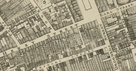
Rocque's Map of 1756 showing Moore's legacy: Moore St, Henry St, Off Lane, Drogheda St and Earl St are all visible.

Rocque’s Map of 1756 showing Henry Moore, Earl of Drogheda’s legacy:  Henry St, Moore St, Earl Street, Off Lane, and Drogheda St

This entire development was laid out before 1728 on what was called Ash Park by the monks of St Mary’s Abbey, where the Earl of Drogheda had taken the Abbot’s House as his city residence. After laying out his new streets, the Earl built Drogheda House, a mansion situated between Earl St and the next street north, now called Cathedral St. The Earl, clearly not wanting to waste an opportunity, called this street Mellefont Place (he was also Baron Moore of Mellefont). A fountain was situated at the front of the house, “pouring water into Drogheda St”. Drogheda St, linking Sackville St (northern end) to the river was by then only a narrow lane, and indeed on Rocque’s map, did not continue to the river.

Sackville St and Gardiner's Mall, c. 1760, by Oliver Grace

Sackville St and Gardiner’s Mall, c. 1760, by Oliver Grace

Wide Street Commissioners Map of planned alterations to Sackville St - compare the width of Sackville and Drogheda Streets. (Dublin City Library - click image to go to source)

Wide Street Commissioners Map of planned alterations to Sackville St – compare the width of Sackville and Drogheda Streets. (Dublin City Library – click image to go to source)

An important map in the Dublin City Library Wide Street Commission archives is shown, outlining the commission’s plans to extend and widen the thoroughfare from the end of Drogheda St through the connection with Abbey St and onto the river. Just 30 years earlier, this was a haphazard cluster of houses. Having widened the section from the river to Abbey St, and the previous widening in 1749 of what became Sackville St, Drogheda’s days were numbered, and the entire length was widened in the 1790s, becoming Sackville St (after a brief time as New Sackville St). This was achieved by Luke Gardiner, later 1st Viscount Mountjoy.

The change from Drogheda to Sackville reflects also the earlier changing land ownership. Drogheda’s reign came to an end following the death of the Earl. The lands passed through the hands of Sir Humphrey Jervis, who sold them to Luke Gardiner around 1714. It was he who laid out Gardiner’s Mall, and the northern stretch of Sackville St; the name coming from Lionel Cranfield Sackville, 1st Duke of Dorset, who was viceroy for the periods 1731-37 and 1751-6.  Gardiner also called his younger son Sackville, so we can assume the families were friendly. As mentioned we had to wait until his grandson Luke continued the street to the river later that century, and Drogheda St disappeared from the map.

Sackville St eventually became O’Connell St, although not as soon as planned. Dublin Corporation, in a rash of apparent nationalism in 1884 (see John Dillon St) opted to rename the street after the Liberator, but was prevented by a court injunction taken by the street’s residents, clearly more loyal to their peers. It wasn’t until independence that O’Connell finally superseded the Viscount and the Earl that preceded him.

Sackville St in the early 19th century (Original image from National Library of Ireland - click to go to source)

Sackville St in the early 19th century (Original image from National Library of Ireland – click to go to source)

Notes

  • Christine Casey (2005) The Buildings of Dublin, Yale University Press.
  • Mrs. James F. Daly (1957) O’Connell Bridge and Its Environs, Dublin Historical Record, 14(3), 85-93.
  • Seamus Scully (1972) Ghosts of Moore Street, Dublin Historical Record, 25(2), 54-63.
  • Maura Shaffrey (1988) Sackville Street/O’Connell Street, Irish Arts Review, 144-149.

Iveagh Market Buildings

Nearly one hundred and nine years ago, Colonel George W. Addison R. E. represented the Iveagh Trust at a ceremony to formally hand over the new Iveagh Markets to Dublin Corporation. Giving his thanks on receiving the deeds of conveyance and keys, the Lord Mayor expressed the hope that the city would continue to benefit from Viscount Iveagh’s munificence, and that he would be spared to continue his noble works.

Iveagh Markets (from the Dublin City Library image collection - click to go to source)

Iveagh Markets (from the Dublin City Library image collection – click to go to source)

This exchange is captured in an Irish Times article in June 1906 which thankfully recorded the ceremony and some detail about the markets; for there is surprisingly little source material elsewhere. The markets themselves came about after clearances around St Patrick’s Cathedral to remove some of the slums there as part of the Iveagh Trust building development. There was a need for a new space for market traders, a need apparently noticed by Iveagh himself:

The state of affairs did not pass unnoticed by Lord Iveagh… and frequently visiting the neighbourhood, was often an observer of the unfortunate conditions under which the street merchants carried on their business; he, therefore, conceived the idea of providing suitable covered accommodation…

OS 25" map showing Iveagh Market (OSi)

OS 25″ map showing Iveagh Markets (OSi)

The location of the markets is just off Francis St, and they are shown clearly on the Ordnance Survey 25″ map. A new road on the north-eastern side of the markets was built—linking John Dillon St to Lamb Alley (the diagonal running left-right across the map shown). Eagle-eyed among you will notice that this new street terminates just before it reaches High St at Cornmarket, and in his address to Addison, the Lord Mayor noted that it would be a great advantage to the scheme if this cul de sac at Lamb Alley could be opened to Cornmarket. As this is now the case, we can assume that Iveagh agreed. The markets were built on the site of Sweetman’s brewery; the site had previously been purchased by Guinness as part of their ever-growing domination of the brewery industry. Sweetman’s don’t appear to have had much luck in situating their brewery; they were previously moved by the Wide Street Commissioners to this location. As well as Sweetman’s, the construction involved the demolition of some houses on Francis St to open up Dean Swift Square.

Entrance to Iveagh Markets

Entrance to Iveagh Markets

Keystone representing Ireland (Hibernia) (from about.com)

Keystone representing Ireland (Hibernia) (from about.com)

The building housed two markets: a market for the sale of old clothes (100 by 150 ft), accessed from Francis St, and a market for the sale of fish, fruit, and vegetables (130 by 80 ft), accessed from John Dillon St. The markets were fitted up with stalls, and the fish stalls were of white glazed earthenware, the first of the kind to be adopted. The building itself was designed by Frederick Hicks, of 86 Merrion Square. It is constructed with Portmarnock red brick and Newry granite, with door and window dressings of Portland stone.A distinctive feature is the keystones, carved with heads representing nations of the world. The centre keystone represents Ireland, with others representing Eastern Turkey, Europe, Asia, Africa, Americas, and for some reason Spain and Israel get their own.

Washhouse on Lamb Alley (Photo: B)

Washhouse on Lamb Alley (Photo: B)

The Act of Parliament which moved the traders away from St Patrick’s Park also included a clause that all clothing for sale was to be disinfected.It is just possible to discern a Public Washhouse and Disinfecting Dept just north of the markets on the map shown above. The washhouse was fitted out with the latest laundry fittings and machinery, with accommodation for 40 washers. In addition, there were four centrifugal wringing machines and 40 hot air drying horses, an iron and mangling room, and if there was time to sit down while doing all this work, a waiting room. The disinfecting department was equipped with three high pressure steam disinfectors and two formaline chambers for clothing not able to take steam treatment.

The management of the entire facility was to be taken on by the Corporation. The Irish Times stated that:

though a further responsibility is thrown on the shoulders of the city fathers, still, everyone will admit it is a worthy one.

Indeed.

Notes

The full Irish Times article is: “The Iveagh Market Buildings” Irish Times, Thursday, July 26, 1906, page 11. The always excellent Dictionary of Irish Architects gives some references to Irish Builder articles on the markets which can be viewed in the National Library.

A house on Cork Hill

It’s easy to miss Cork Hill, a short street connecting Lord Edward Street and Dame St at City Hall. I measure its length at 35 paces, and although I am tall, I reckon it must be one of the shortest streets in Dublin. Cartophiles will correctly argue that it is a little longer, as the hill officially includes the plaza to the right of City Hall, connecting Castle St. Whatever its length, this short dog-leg joining Lord Edward, Dame, Castle, and Parliament streets is packed full of history; no surprise given its location adjacent to the Castle. As Maurice Craig puts it, it was very much at the centre of things.

The street itself takes its name from the Earl of Cork, after he built Cork House there in the early 1600s on the site of the present City Hall. Cork House was itself located on the site of the church St Mary del Dam, from which we get the name of Dame St.  Also known as the Great Earl, Richard Boyle was a self-made man who took advantage of the plantation of Munster to make his fortune. Having secured the favour of Elizabeth I, he collected political titles, becoming Privy Councillor for Ireland in 1612, and Member of Parliament for Lismore in 1614. The Irish Parliament was held in Dublin Castle at the time.

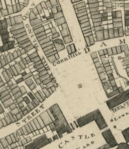
The area around Cork Hill as captured by Rocque on his map of 1757.

The area around Cork Hill as captured by Rocque on his map of 1757.

Tempting as this short commute might have been, it doesn’t appear that Boyle lived in Cork House. The building was occupied by the Royal Exchange until 1683, when that operation moved to the Tholsel nearby (just visible on Rocque’s map, above). It subsequently became home to a variety of traders; most notably printers and coffee houses. Lucas’s Coffee House, one of the most fashionable places to loiter in the city, was one of the last occupiers.

Fashion could not save the house or the area from the Wide Street Commissioners. Cork House was demolished in 1768 in a grand plan to widen Parliament St. Parliament St—which doesn’t exist on Rocque’s map—was to be the new grand wide and convenient street linking City Hall to the planned construction of Essex Bridge. Walking from the right on Rocque’s map shown, we can see Cork Hill following on from Dame St, but neither Parliament nor Lord Edward St are extant; Castle St is the main thoroughfare. The entire area was a bit chaotic.  The narrow network of streets meant that maintaining law and order was difficult. At Cork Hill, a contemporary account recorded that:

pedestrians passing Cork Hill after dark were frequently insulted and maltreated by the numerous chairmen surrounding the entrances to Lucas’s Coffee House and the Eagle Tavern, the waiters of which establishments supported them in those engagements by pouring pails full of foul water upon their opponents.

Changes were needed. Trinity College Dublin led the charge at the other end of Dame St by demolishing the Jacobean frontage of college, itself less than 70 years old, and installing the present frontage. Copious plans of the area exist for around 1766 in the Wide Street Commissioners’ archives, lovingly cared for by Dublin City Archives. But before we look at those, an earlier glimpse is available. A pair of maps of the area dated 1751 (showing the alignment at the time) and 1753 (showing planned changes) are described by MacDowel Cosgrave (1918). A section of interest is shown. In this Survey of the present streets leading to His Majesty’s Royal Pallace or Castle of Dublin. Novr 9th, 1751, Cork Hill is clearly visible. 

Extract of a survey of the present streets leading to His Majesty's Royal Pallace or Castle of Dublin. Novr 9th, 1751

Extract of a survey of the present streets leading to His Majesty’s Royal Pallace or Castle of Dublin. Novr 9th, 1751

Gloriously, this map has the building locations annotated, and inspecting the legend, one finds that Cork House is located at position number 34, sandwiched between Mr Butler, printer (33), and Mr Mear’s mercers shop (35).

Proposal for new street linking Dame St to river. Point a marks proposed location of statue of George I

Proposal for new street (between the two ‘C’s) linking Dame St to river. Point a marks proposed location of statue of George I

More exciting is the proposal of 1753. In this we see that the new alignment of what would become Parliament St is proposed – 46 feet wide, running from the river south to Dame St. At the junction, a large square on the south side was planned. This was to be named Bedford Square after the Lord Lieutenant of the time, and there is even an annotation to include a statue in the centre. This was to be of George I, relocated from the old Essex Bridge. Losing out were buildings number 25 (Mr D’Olier, Goldsmith), 26 (Mr John Ross), and 27 (Mr Fords, Print Shop), and one presumes, the buildings around the new square, including Cork House.

Extract of the Wide Street Commissioners map of the area around Cork Hill (click to link to Dublin City Library source)

Extract of the Wide Street Commissioners map (No. 499) of the area around Cork Hill (click to link to Dublin City Library source). ‘A‘ marks the proposed location of the statue.

There is a significant number of maps available in the Dublin City Library image collection documenting the Wide Street Commissoners plans for the area, but perhaps the one to select to continue our story here is Map No. 499, shown. This shows Dame Street, Castle Lane (now Palace Street), Swan Alley (now Exchange Court), Parliament Street, Cork Hill, Castle Street, Castle Yard and vicinity. The site of Cork House is now annotated as “Lot from Swan Alley to Cork Hill”, and it is evident that plans for a square and statue of George I were still being considered by the Commissioners.

Rocque's map of 1756 showing the proposed Bedford Square

Rocque’s map of 1756 showing the proposed Bedford Square

The letter A on the map marks “a pedestal for the Statue of his Majesty George I which faces Parliament St and Castle St.” Parliament St is now shown, with “New Buildings” lining either side. The intention to complete the square obviously convinced Rocque, who in his 1756 map showed the square, to the south of Cork Hill, complete with statue. The square itself looks like Rocque rubbed out previous engravings of existing buildings. His 1757 map shown at the top of the article corrected the prediction.

As we now know, the square was never built, but Cork House was demolished in 1768, and City Hall construction began the following year. The infamous approach of the Wide Street Commissioners on Parliament St is well documented, when “public consultation” was replaced by unroofing houses in the middle of the night to get people to leave. While it would be some time (and a national rebellion) before Lord Edward St would appear, the area was beginning to take the form we recognise today.