Last Post on James’ St

Having served the area since 1891, James’ St post office recently closed and is currently for lease. It was one of several post offices designed by “the always interesting” J. Howard Pentland. Others in Dublin include Ballsbridge, Phibsborough (demolished and rebuilt in 1960), and Blackrock in 1909.  Maire Crean’s magnificent book “Lost Post” provides substantial detail on James’ St post office, including the original proposal of the floor plan, now kept in the National Archives.

James’s Street Former P.O.; Part Original Ground Floor Plan (National Archives of Ireland, reproduced in Crean)

James’s Street Former P.O.; Part Original Ground Floor Plan (National Archives of Ireland, reproduced in Crean).

James’s Street Former P.O.; Original Elevation (National Archives of Ireland, reproduced in Crean).

James’s Street P.O.; Original Elevation (National Archives of Ireland, reproduced in Crean).

The public office is visible to the left of the plan, and the sorting office to the right. Crean also treats us to the original elevation – clearly it was originally intended to be a Gothic affair. The door to the public office is on the left on the plans, but from the existing building, we can see it is on the right.

The existing building is part of a trio of red-bricked buildings on the site: two at the pavement, and one in between; a three-storey building recessed from the road. Casey seems doubtful that such a grand building could be for a postmaster, and I can’t find anything in the 1901 Census to counter her opinion. The Post Office in that Census was given number 106, and was of course uninhabited. Using that numbering system, 105 and 104 are the adjoining buildings, and they too were unoccupied in 1901. By 1911, the numbering had shifted to what we currently have: the post office at no. 109, and the large house at 108 was a boarding house for four brewers from England and four domestic servants. 107 remained unoccupied.

Penny Post History

Stafford Johnson gained a substantial amount of information from two pieces of paper found in a bin. Most other remaining archives were destroyed.

Postal history can be traced back to James’ St much earlier than 1892. Dublin had an innovative and efficient postal system known as the “Penny Post”, which was established in 1773. The city joined London to be unique in the world with such a system, although according to Stafford Johnson—who has provided us with one of the rare monographs on this topic—Dublin “has some matter for pride in the fact that it maintained the general character of the Penny Post unaltered until the end.

The Penny Post operated in parallel to the pre-existing General Post system. From 11th October 1773, letters not exceeding four ounces could be delivered from the Penny Post Office in the GPO yard or any of eighteen Receiving Houses around the city, at a cost of one penny. The receiving houses were named in the original correspondence and included Mr. Charles Wren, Hosier, at the Sign of the Stocking, Francis-street near the Combe, Mr. Bredberry, Grocer, at the Sign of the three Swedish Crowns, George’s Quay and Mr. Bourke, Grocer at the Black Boy and Sugar Loaf, Capel-street near Essex-bridge. By 1810, there were 54 receiving houses in the city, and 29 country receiving houses, the extra distance to the country (suburban areas) costing 2 pence.

Doorway, James St Post Office

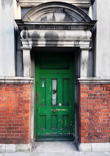
Doorway, James’ St Post Office (Photo: B)

The original system involved a pre-payment of one penny which was given in to the Penny Post Office or receiving houses. Letters that did not have the accompanying penny were opened and returned to the sender. A plea was made to be as precise as possible with the address, and those intended for lodgers were to name the landlord or the sign (on the building) to assist the post men.These men wore a distinctive uniform from 1810, and like their colleagues in the General Post system, rang a bell when on collection duty.

In 1810, the pre-payment system was abandoned. The official reason isn’t known, but Stafford Johnson offers with some confidence his theory that pre-payment ran counter to the public sentiments of the time. Payment on delivery would be preferred as it secured a safer delivery, and poorer people could take advantage of the system by refusing to accept delivery (and hence avoid the charge) while learning who the letter was from. Apparently secret codes were used so that the recipient could interpret the message with accepting the letter. Nonetheless, the system was a successful and efficient means of communication in the city. The post-masters general were eager to highlight the benefit of their system and regularly published the notice:

So expeditious and regular is the dispatch and delivery of letters by this Office that two persons residing in the most distant parts of the City from each other, may write four letters and receive three answers in the day for the trifling expense of one penny on each.

James St Post Office (Photo: B)

James’ St Post Office (Photo: B)

Back at James’ St, a receiving house opened on the street in 1809/10, and we can propose that this house is a precursor to the post office mentioned at the head of the article. The listing of a receiving house at No. 75 in the 1862 street directory adds some weight to this proposal. Here, William Madden, M.D. operated his medical practice, and acted as a Post Office Receiver. In addition to the house on James’ St, a second receiving house opened on Echlin Lane (now Echlin St) after 1810. The latter joined receiving houses at Broadstone Hotel and Portobello Hotel linking the city system with the Royal and Grand canal harbours (see In the fields off James’ St).

The Penny Post system ended in 1840, because of a combination of factors, not least the duplication with the General Post system. Stafford Johnson closes his article with the following:

Looked at as a whole, the Penny Post was worthy of the City and fulfilled its functions truly and well. For 66 years it gave a service which for cheapness and quickness has never been equalled. All this was done by men on foot, and to-day, in spite of the advantages of modern science, there is nothing to come up to that old system of which all that remains is a memory and some faded old letters.

Letter Box on No 107 James St

Letter Box on No 107 James’ St (Photo: B)

You can receive email updates when a new post is published by subscribing below.

Notes

The Coombe Hospital Portico

The Portico of the Coombe Hospital, built 1877

The Portico of the Coombe Hospital, built 1877

The Coombe Hospital, now on the upper reaches of Cork St began life in The Coombe itself. After the Meath Hospital moved from the site to Naboth’s vineyard on Long Lane in 1822, the hospital was bought by John Kirby, President of the Royal College of Surgeons, who ran it as a general hospital. According to a contemporary report, the location was apt:

This charitable institution stands in that part of the city where poverty and disease prevail in their most calamitous degree of aggravation; and where accidents, in their severest forms, constantly occur, and hourly demand admission into some asylum where suffering may be alleviated and life preserved. [Wright, 1825]

A plaque on the portico tells us what happened next:

Towards the end of the year 1825, two women whilst making a vain attempt to reach the Rotunda Hospital perished together with their new born babies in the snow. When this became known a number of benevolent and well-disposed persons founded “The Coombe Lying-in Hospital” in the year 1826 for the relief of poor lying-in women.  Leading the Charitable Committee was a Mrs Margaret Boyle of Upper Baggot St, Dublin.

Coombe map

Coombe Hospital, OSi

Kirby was replaced as Master in 1836 by Hugh Carmichael, and the name of the hospital changed to the ‘Coombe Lying-in Hospital and Dublin Ophthalmic Dispensary’ — Carmichael had an interest in ophthalmology. In 1838, it was reported that the hospital had 42 beds and “daily affords advice and medicine to about one hundred and fifty extern patients.” The original building deteriorated and in in 1867, the patients were transferred to another hospital on Peter St run by Kirby. Benjamin Guinness and others provided funds for a new hospital which opened in 1877. A dispensary is visible along Brabazon St on the later nineteenth century map of the area, labelled “Guinness Dispy”.

A century after the original building closed, this new hospital also closed, and the new Coombe Hospital opened on Cork St. The portico is all that remains.

The plaque continues:

The portico surrounding this plaque formed the entrance until the year 1967 when the hospital moved to a new location in Dolphin’s Barn. It has been retained and restored by Dublin Corporation as a memorial to the many thousands of mothers who gave birth to future citizens of Ireland in the Coombe Lying-in hospital and also to the generosity of the staff and friends of the hospital.

The housing scheme which was subsequently erected on the site by Dublin Corporation was officially opened by the Right Honourable the Lord Mayor, Alderman Fergus O’Brien T. D. , on 20th November 1980.

Notes

  • David Mitchell (1989) A Medical Corner of Dublin (1711 to 1889), Dublin Historical Record, 42(8), 86-93.
  • L. B. Somerville-Large (1964) Dublin’s Eye Hospitals in the 19th Century, Dublin Historical Record, 20(1), 19-28.
  • You can see a photograph of the original building at Archiseek.

Reginald Street, The Coombe

The very pretty Reginald Street and Gray Street and their associated squares were built in 1880-1882 by the Dublin Artisan’s Dwelling Co. The company was established in 1876 and was chaired by one of the great Victorian philanthropists, Sir Edward Cecil Guinness. It went on to build over 3,600 dwellings around Dublin, which were intended to house the working class of Dublin. Initially, rental costs meant that they were only feasible for skilled labourers, although a (cursory) analysis of the 1911 Census shows that the majority employer of the residents was the brewing industry, so Guinness’ plan to house his workers appears to have worked out well.

Reginald Street

Reginald Street

The small squares off the Reginald Street/Gray Street result in the whole forming a cruciform pattern. Houses in these squares are single storey and likely followed the typical three room plan; front door into the living room with a contained scullery leading out into the rear yard, and two bedrooms off to the side. Despite being a couple of minutes from a very busy Meath Street, the whole area exudes calm.

The Sacred Heart Statue at Reginald and Gray St was a fountain

The Sacred Heart Statue at Reginald and Gray St was a fountain. The plaque reads: “Erected by the Parishioners of St Catherine’s to honour the glory of God and in commemoration of the centenary of the Emancipation 1929

The street names give plenty of notice that this was the Earl of Meath’s Liberty. Reginald Brabazon was the 12th Earl of Meath when the complex was built. No matter how much the romantic in me wishes that Reginald married a Gray, the street he intersects, this is not the case, and Gray Street is more likely to be named after Sir John Gray, the man responsible for bringing clean water supply to Dublin from the Vartry reservoir in the Wicklow mountains. Rather appropriately, the intersection of Reginald and Gray featured a fountain. This was replaced with a statue of the Sacred Heart in 1929, ostensibly to commemorate the centenary of Emancipation, although it can’t just be a coincidence that this is also the year of the death of Reginald, an arch-Unionist and Imperialist. Divine intervention couldn’t save the statue from collision with a lorry, and the current version was that restored to mark the visit of Pope John Paul II in 1975. More on the statue and the pope’s visit, including some attractive photos, are on the Built Dublin Site.

Reginald has the last laugh though. The eponymous street ends in Meath Terrace, and he is also remembered in three of the four squares in the complex: Brabazon Square, Reginald Square and Meath Square. For good measure, the eastern edge is flanked by Meath Street, and Earl Street is nearby. Vota vita mea

Brabazon Square

Notes

Christine Casey has more details on the Artisan’s Dwelling Co, including some sketches of typical houses and a floor plan of a bungalow, described above. Casey, C (2005) The Buildings of Dublin, Yale University Press

A Long Lane

Long Lane was longer

Long Lane was longer

While it doesn’t make (as) much sense now, Long Lane was a very appropriate name for the street that ran from New Street/Clanbrassil St to Wexford St. Its length was originally 500 metres, but this was bisected by Bride St/Heytsbury St when that street was laid out in 1846.

Long Lane exists on Rocque’s map of 1760 and the plan of the city in 1797. This area was the Earl of Meath’s Liberty, and the most significant building on the street was the Meath Hospital. This was built on the south side of Long Lane in 1821, moving from its earlier location in The Coombe (the portico of the original building still stands in The Coombe). The hospital was built on what Rocque’s map calls “Naboth’s Vineyards”, which had been bought by Dean Swift in 1722 (it was also called Dean’s Vineyards). Writing in 2008, Walsh states that the wall between the hospital and Long Lane includes sections built by Dean Swift.

meath hospital

The site was purchased from him after a donation of £6000 from Thomas Pleasants, whose money went to build the new hospital. He did not live to see the hospital opened. Money had been sought from the Duke of Leinster and Lord Powerscourt, but in the end Pleasants was the main benefactor. He was rewarded with a street in his own name nearby.

The northern side of Long Lane had on the early maps a Cabbage Garden marked on an area of about two acres. This included the site of the current DIT building on Kevin St., and my own office. Strangely, the recording of brassicas at this site continued onto the early Ordnance Survey map, which seems rather quaint. After its bisection by Bride St., the eastern end of Long Lane initially retained its original name. Buildings here included St Sepulchre’s Marshalsea, now the site of a modern apartment complex, and of course St Kevin’s Church, now a ruin. However, by the end of the century, the eastern end of the lane had been renamed Camden Row. The cabbage gardens were also gone by this stage; replaced by saw mills. The Earl of Meath’s legacy is still visible in a row of houses on the remaining section of Long Lane known as Meathville Terrace.

Notes:

  • Peter Gatenby (2005) The Meath Hospital, Dublin, Dublin Historical Record, 58(2), 122-128.
  • David Mitchell (1989) A Medical Corner of Dublin (1711 to 1889), Dublin Historical Record, 42(8), 86-93.
  • Dave Walsh, The Ghosts of Archbishop Marsh, Swift and Stella, Dublin Historical Record, 61(2), 194-196.